


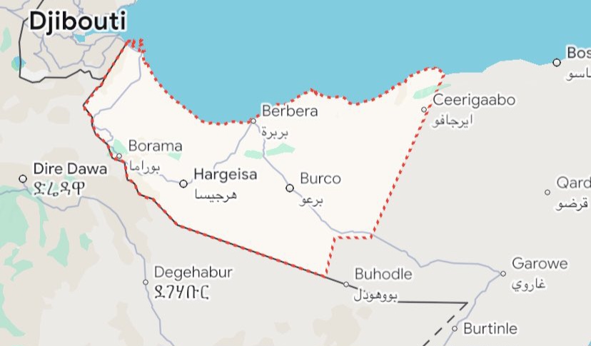
Map showing Somaliland's erased borders on Google Maps after Somalia's lobbying, sparking sovereignty concerns. © Buraopost
×
![Enlarged view of Somaliland map border controversy]()
Subscribe to BBN Daily
Join our newsletter for the latest news and updates, delivered straight to your inbox.
Thank You!
We've received your request. Please check your email to confirm your subscription.
For more than thirty years, Somaliland has charted its own destiny, declaring independence in 1991 after the collapse of Somalia’s central government and the brutal civil war that devastated the north. Though it has yet to gain formal recognition from the United Nations or any major power, Somaliland has functioned as a self-reliant state with its own democratic elections, constitution, military, and currency. Generations of Somalilanders have lived under their flag, celebrated their own national holidays, and built a society defined by peace and stability in stark contrast to the turmoil that has plagued southern Somalia. Yet now, with a single update, Google has removed the dotted boundary that once separated Somaliland from Somalia on its global platform, rendering Hargeisa just another Somali city in the eyes of millions of online users.
The reaction in Somaliland has been swift and fierce. Citizens, students, and officials alike describe the move not as a minor cartographic adjustment but as an existential insult. To them, it is nothing less than an act of erasure—a denial of history, identity, and the sacrifices of thousands who fought and died for independence. “This is not just about maps. This is about our sovereignty,” a senior Somaliland diplomat told Buraopost in an exclusive interview. “Google has chosen to side with Mogadishu’s political agenda. This undermines our stability and disrespects the will of millions of our citizens.”
The anger stems not only from the immediate change but from the suspicion that it was orchestrated. For years, Somalia’s federal government has used every diplomatic lever available to assert its claim over Somaliland, even as it struggles to govern its own fragmented territory. According to political observers, Mogadishu has now extended this battle into the digital realm, persuading technology companies and international organizations to present a “one Somalia” narrative. With Google Maps being the most widely used navigation system in the world, its influence on perception is unmatched. “The Somali government understands that recognition battles are no longer fought only in embassies,” explains Dr. Amina Warsame, a political scientist specializing in Horn of Africa affairs. “They are fought in the media, in tech companies, and even on Google Maps. By persuading Google to alter Somaliland’s depiction, Mogadishu is claiming a symbolic victory.”
For Somalilanders, however, the consequences of this digital erasure run far deeper. Many recall vividly the brutality of the 1980s, when Siad Barre’s regime bombed cities like Hargeisa and Burao, leaving entire neighborhoods in ruins and thousands dead. The declaration of independence in 1991 was not only a political decision but a survival mechanism, a chance to rebuild their lives free from the oppression of Mogadishu. The state that emerged has endured, built on resilience and sacrifice. To see its borders deleted on a global platform is, in the words of one Hargeisa university student, “like being told we do not exist.”
The timing of Google’s update also raises alarms. The Horn of Africa remains one of the most volatile regions in the world, with Somalia battling internal divisions, Ethiopia facing secessionist pressures, and Yemen across the Gulf of Aden trapped in a grinding civil war. Somaliland has long been regarded as a rare island of peace, running relatively stable elections and maintaining order even without international recognition. Critics now warn that undermining this fragile sovereignty in the digital sphere could provoke resentment and destabilize the region further. “This could fuel anger not only against Somalia but also against international actors seen as complicit,” says Dr. Warsame. “In a region where emotions quickly turn into conflict, this is dangerous.”
The issue also highlights the immense power wielded by technology giants in shaping geopolitical narratives. Google has historically claimed neutrality in depicting disputed territories, often aligning with the positions of the United Nations. But neutrality in practice often means adopting the perspective of the stronger or more internationally recognized party. By absorbing Somaliland into Somalia’s map, Google is effectively endorsing Mogadishu’s claim, regardless of the reality on the ground. “Big tech cannot hide behind neutrality,” argues journalist Abdilahi Hassan. “When you erase borders, you are taking a side. When you redraw maps, you are rewriting history. Google may claim it is following international standards, but the truth is, it has chosen politics over people.”
This is not the first time Google Maps has faced criticism for politically charged cartography. Its depiction of Crimea following Russia’s annexation, its handling of Kashmir, and its treatment of the Israel-Palestine conflict have all drawn accusations of bias. Each case has underscored how maps are not just tools for navigation but instruments of power, identity, and legitimacy. Somaliland now joins this list of contested geographies, where digital lines carry the weight of real-world consequences.
Within Somaliland, the update has sparked renewed calls for unity and defiance. Online campaigns have emerged demanding Google reverse the decision, while diaspora communities in Europe and North America are mobilizing to pressure the company through petitions and lobbying. Government officials in Hargeisa are preparing formal complaints and urging international partners to recognize the destabilizing effect of such digital interventions. The incident has also strengthened nationalist rhetoric, reminding Somalilanders that their decades-long quest for recognition is far from over. As one activist put it, “Google can erase us from its map, but it cannot erase us from history.”
The emotional toll of the change is compounded by practical concerns. For businesses, aid organizations, and travelers, maps play a crucial role in logistics, planning, and communication. When Somaliland disappears from a widely used platform, it complicates navigation, misrepresents governance structures, and risks creating confusion in international operations. Aid destined for Hargeisa could be misdirected, foreign investors may hesitate, and global awareness of Somaliland’s distinct political reality could erode.
The controversy is likely to intensify in the coming weeks. Whether Google reverses course or holds its position will determine not only its credibility but also its relationship with millions of Somalilanders who feel betrayed. For the people of Hargeisa and beyond, this is more than a matter of digital cartography—it is a struggle for recognition, dignity, and the right to exist on their own terms. The stakes could not be higher.
In the broader picture, the Google Maps update has revealed how fragile sovereignty has become in the digital era. In the past, borders were defended by armies and treaties; today, they are vulnerable to algorithms and platform policies. The removal of Somaliland’s borders demonstrates how global tech firms, often unintentionally, have become actors in geopolitical conflicts. Their decisions, whether deliberate or procedural, carry consequences that can fuel anger, reshape identities, and even ignite wars.
For Somaliland, the battle continues on multiple fronts—diplomatic, political, and now digital. The sense of betrayal runs deep, but so does the determination to endure. After three decades of building a functioning state against the odds, Somalilanders insist they will not be erased by a line on a screen. They remain steadfast in their belief that recognition will come, even if the world’s most powerful companies and governments resist.
As the sun sets over Hargeisa, a city rebuilt from the ashes of war, the resilience of its people remains unshaken. They have weathered bombardments, poverty, and international indifference. A digital erasure on Google Maps, painful as it is, will not undo their sovereignty. It will only strengthen their resolve.
And so the story continues—of a people fighting not only for recognition but also for the right to appear on the world’s maps as they truly are. Until then, Somaliland lives in the hearts of its citizens, visible or not, on the screens of the world.

